Table of Contents >> Show >> Hide
- What a “Mega-Tsunami” Really Means
- How an Earthquake Turns Into a Tsunami
- What the Simulation Usually Shows Step by Step
- Real Events That Shape Today’s Tsunami Simulations
- Could This Happen in the United States?
- What Simulations Get Right, and What They Still Cannot Promise
- What You Should Do If the Simulation Ever Becomes Real
- Experiences That Make the Topic Feel Real
- Final Thoughts
If you have ever watched a mega-tsunami simulation and felt your stomach do a tiny backflip, congratulations: your survival instincts are working beautifully. These animations are dramatic for a reason. They take a process that happens across hundreds or thousands of miles of ocean and turn it into something your brain can actually understand. One moment the seafloor jerks upward. The next, rings of energy race across the map like the planet has dropped a bowling ball into the Pacific. Coastal colors change. Arrival times tick down. And suddenly the phrase earthquake tsunami stops sounding like a geology lecture and starts sounding like a very urgent calendar reminder.
Still, the best tsunami simulation is not just digital doom with prettier shading. It is a scientific tool. It shows how an undersea earthquake can displace an entire column of water, how that energy moves through the deep ocean at astonishing speed, and how coastlines can turn a seemingly modest offshore wave into a much more dangerous onshore flood. For coastal communities, emergency planners, ports, and families living near the shore, this is not abstract science. It is a preview of how minutes, topography, and preparedness can decide whether a bad day becomes a catastrophe.
So what would actually happen if an earthquake caused a mega-tsunami? The answer is less Hollywood wall-of-water at every beach on Earth and more complex, physics-driven chain reaction. And honestly, reality is scary enough without special effects doing extra credit.
What a “Mega-Tsunami” Really Means
Let us start with the phrase itself, because the internet loves the term mega-tsunami the way a raccoon loves an unlocked trash can. In everyday headlines, it often means “really big tsunami.” In scientific discussions, the label is more often associated with extraordinary waves produced by giant landslides or volcanic collapses, including ancient Hawaiian examples. That matters, because not every earthquake-generated tsunami qualifies as a “mega-tsunami” in the strictest sense. But an earthquake can absolutely trigger a devastating tsunami capable of extreme coastal flooding, destructive currents, harbor damage, and widespread inundation.
That is why the most useful simulations do not focus on catchy labels. They focus on measurable things: rupture length, fault type, seafloor uplift, wave amplitude, travel time, current speed, inundation extent, and runup. That may sound less cinematic than “monster wave apocalypse,” but it is much more helpful if your actual goal is not becoming seafood by surprise.
Another myth worth retiring: bigger headline does not automatically mean bigger science. The U.S. Geological Survey notes that magnitude 10 or larger earthquakes are not realistic because no known fault is long enough. So when a simulation claims to show a planet-breaking quake followed by an ocean-ending tsunami, it is drifting from hazard modeling into fan fiction with water.
How an Earthquake Turns Into a Tsunami
1. The fault ruptures and the seafloor moves
The most dangerous tsunami-generating earthquakes usually occur in subduction zones, where one tectonic plate dives beneath another. When the locked edge finally slips, part of the seafloor can suddenly rise or drop. That vertical displacement pushes the water above it out of place, and the ocean immediately tries to rebalance itself. Spoiler: it does not do that politely.
Not every earthquake makes a serious tsunami. The event usually needs to be shallow, under or near the ocean, and capable of significant seafloor displacement. Thrust faults are especially efficient at this. Some so-called “tsunami earthquakes” produce larger waves than their magnitude alone would suggest because of how shallowly and slowly the rupture occurs. In other words, the ocean does not only care how powerful the quake is. It cares how the crust moved.
2. The wave races outward across the ocean
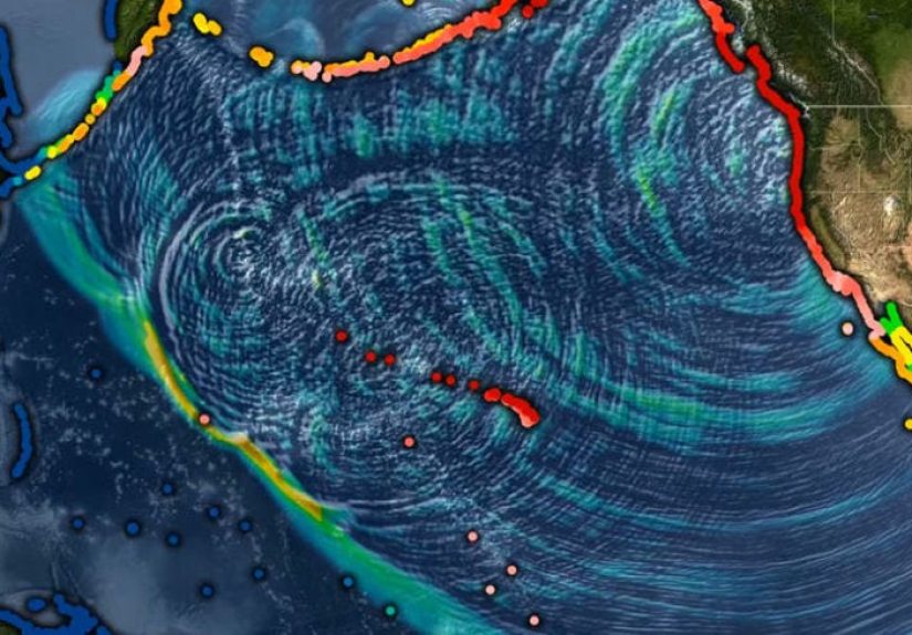
In deep water, a tsunami does not usually look like the curling wave from a surf video. It is more like a huge pulse of energy moving through the entire water column. The wavelength can stretch for hundreds of miles, while the height offshore may be small enough that ships barely notice it. That is the rude magic trick of a tsunami: it can cross an ocean quietly and then become terrifying near land.
This is why tsunami modeling matters so much. NOAA’s forecast systems use precomputed earthquake scenarios, real-time observations, and numerical models such as MOST to estimate how the wave will propagate. Scientists compare the model with data from DART buoys, tide gauges, and increasingly even satellites. The goal is speed, accuracy, and fewer terrible surprises.
3. The coastline reshapes the threat
As the wave enters shallower water, it slows down, shortens, rises, and intensifies. Bays, harbors, underwater ridges, and coastal shape can focus energy in one location while sparing another area nearby. That is why tsunami hazard maps can look maddeningly uneven. One stretch of coast gets strong currents and limited flooding; another gets severe inundation; a harbor across the bay behaves like it was designed by chaos itself.
A good mega-tsunami simulation usually shows this beautifully. The wave pattern is not uniform. It bends, reflects, piles up, and interacts with the seafloor. If the coastline is low-lying, water can move far inland. If the source is local, communities may have only minutes to react. There is no time for debate, no time for a long group text, and definitely no time for someone to say, “Let’s just see what happens.”
What the Simulation Usually Shows Step by Step
If an earthquake-generated mega-tsunami scenario were modeled in a realistic way, the sequence would unfold roughly like this.
The first few minutes: confusion, alerts, and natural warning signs
People near the coast may first feel a strong or long earthquake. That alone can be the warning. In a local tsunami scenario, official alerts may follow, but nature may beat the notification system to your ears. A sudden roaring sound from the ocean, strange ocean withdrawal, or rapid rise of water are classic danger signs. In some places, the first visible change is not a crest but a drawdown, where the water seems to pull away before the next surge comes in.
The first wave: dangerous, but not always the biggest
This is where simulations are especially useful because they correct a common misunderstanding. Tsunamis often arrive as a series of waves, not one heroic splash followed by a neat ending. The first wave may not be the largest. Dangerous flooding and currents can continue for hours, and in some situations even longer. A person who returns too early because “the water already came and went” is making the worst kind of optimistic mistake.
Harbors, rivers, and low-lying areas become force multipliers
Tsunami energy does not stop at the beach. It can surge into harbors, up rivers and estuaries, and across roads, parking lots, and neighborhoods. Currents can shred docks, move boats like bathtub toys, and turn debris into battering rams with zero manners. Even a tsunami that does not look enormous in photos can be extremely destructive because of the speed and force of the moving water.
Later waves and surges keep the hazard alive
The simulation would likely continue well after the first arrival because the danger does not end when the initial surge retreats. Reflections, secondary waves, and complicated harbor oscillations can keep water moving in and out. This is one reason emergency officials tell people to stay out of hazard zones until the all-clear is given. The ocean is not done just because it briefly looks bored again.
Real Events That Shape Today’s Tsunami Simulations
Alaska 1964
The Great Alaska Earthquake and Tsunamis remain one of the most important U.S. examples. NOAA notes that the main tsunami produced local runup of more than 30 meters along Alaskan shorelines, with more than 60 meters reported in Valdez Harbor, likely influenced by a landslide. It also caused damage across the Pacific. Modern simulations of that event show just how far forecasting has come. In 1964, there was no deep-ocean real-time detection network like today’s DART system. Now, model forecasts can be constrained by open-ocean observations much more quickly.
Japan 2011
The 2011 Tohoku disaster remains a benchmark for tsunami science. USGS simulations and hazard assessments have been used to compare generation, propagation, and inundation models against what actually occurred. One major lesson was humbling but useful: relying on earthquake information alone can underestimate the tsunami in some cases. The best forecasts improve when real observations are folded into the model as the event unfolds.
Cascadia 1700
If you live in the Pacific Northwest, the Cascadia Subduction Zone is the geological equivalent of the quiet person in the office who could absolutely flip the conference table. USGS research combining sediment cores and advanced modeling continues to refine our understanding of the 1700 Cascadia earthquake and tsunami. That event affected the Pacific Northwest coast and sent a tsunami all the way to Japan. For modern hazard planning, Cascadia is not ancient trivia. It is a serious scenario.
Kamchatka 2025 and the new era of detection
Recent NASA and NOAA work shows how tsunami science is becoming faster and smarter. During the July 2025 Kamchatka event, NOAA used DART observations and modeled source inversion to refine forecasts, while NASA’s GUARDIAN system and SWOT satellite observations helped detect and validate the tsunami’s behavior. That is a big deal. The future of tsunami warning is not one magic instrument. It is layered evidence: seismic data, buoy data, tide gauges, atmosphere-sensing tools, and satellite measurements all working together like a very nervous but very competent orchestra.
Could This Happen in the United States?
Yes, but the exact form depends on where you are. Alaska, the Pacific Northwest, Hawaii, and U.S. territories in the Caribbean and Pacific all face tsunami risk. FEMA has warned that tsunamis could account for more than $1 billion in average annualized losses across the United States, which tells you this is not a niche concern reserved for geology professors and people who own too many contour maps.
In the Pacific Northwest, the big worry is a local Cascadia event, which could leave little time between earthquake and wave arrival. In Alaska, local landslide-enhanced tsunamis add another layer of complexity. In Hawaii, long-travel Pacific sources matter because distant earthquakes can still send dangerous waves. The East Coast is generally at lower risk than the Pacific, but “lower” is not the same as “none.” Hazard planning exists because the ocean does not care about regional stereotypes.
What Simulations Get Right, and What They Still Cannot Promise
The best tsunami simulation can do several things brilliantly. It can show travel time. It can identify likely inundation zones. It can compare one earthquake scenario with another. It can help officials draw evacuation maps, improve port planning, and test warning decisions. It can even reveal where modest offshore wave heights might become serious coastal flooding because of local geography.
But simulations are not crystal balls wearing lab coats. They depend on assumptions about rupture area, slip distribution, depth, bathymetry, and shoreline details. A slightly different rupture pattern can send more energy into one coast and less into another. Local landslides can make a bad event worse. Tidal stage can affect flooding. Infrastructure changes can alter flow. A model is powerful because it narrows uncertainty, not because it eliminates it.
That is the real value of these simulations: they turn uncertainty into something communities can plan around. They do not promise perfection. They make preparation possible.
What You Should Do If the Simulation Ever Becomes Real
If you are at or near the coast and feel a strong or long earthquake, do not wait around for the ocean to file paperwork. Once the shaking stops, move immediately to high ground or inland if you are in a tsunami hazard zone. Official alerts are important, but natural warning signs may be your first or only warning in a local event.
Stay away from beaches, harbors, river mouths, and shorelines until officials say the danger has passed. Remember that the first wave may not be the biggest. Dangerous currents can continue for hours. If you do not have a mapped safe place, public guidance commonly points people toward the highest ground they can reach, or as far inland as possible.
This is where the humble evacuation sign deserves a round of applause. It is not glamorous, but it is the kind of practical friend who helps you move apartments and never asks for pizza reimbursement.
Experiences That Make the Topic Feel Real
One reason tsunami simulations stick in people’s minds is that they translate a giant geophysical process into ordinary human moments. You are not just watching colored water spread across a digital coastline. You are imagining the marina where people drink coffee at sunrise. The road by the elementary school. The boardwalk where tourists argue about sunscreen. The stretch of beach where everybody thinks they have plenty of time, right up until they do not.
For many people, the first real encounter with tsunami science is not a disaster at all. It is a classroom animation, a museum display, a weather segment, or a county evacuation map posted online. At first it feels distant, almost like a science-fiction trailer narrated by topography. Then you recognize a place name. Then another. Suddenly the simulation is not showing “a coast.” It is showing your coast, or the one where your relatives live, or the one where you planned a summer trip and packed way too many snacks.
Emergency drills add another layer of reality. Coastal communities that practice tsunami evacuation learn quickly that the challenge is not only understanding the wave. It is understanding people. Some move fast. Some freeze. Some look for family. Some want to drive even when walking is faster. Some waste precious minutes filming the ocean because apparently every century produces new volunteers for the “I ignored the warning signs” documentary. Simulations help expose these human habits before a real event tests them under pressure.
There is also a strange emotional effect that comes from watching the clock in a simulation. A distant-source tsunami may show hours between earthquake and arrival, which sounds reassuring until you realize how much has to happen in those hours: detection, confirmation, official messaging, local interpretation, public response, transportation decisions, harbor management, school action, hospital planning, and plain old convincing people that the warning is real. A local-source tsunami is even more intense. In those scenarios, the simulation almost feels rude in its honesty. It says: if the ground shakes hard and long, the schedule has changed. Move now.
People who live near the coast often describe preparedness as a balancing act between respect and routine. You cannot spend every beach day staring at the horizon like a Victorian lighthouse keeper. But you also cannot treat tsunami hazard maps as decorative art. The healthiest mindset is practical familiarity: know the route, know the elevation, know the warning signs, know where family members should meet, and know that the ocean does not always send a formal invitation before it misbehaves.
There is something reassuring about that, too. Simulations are scary, yes, but they are also empowering. They replace vague dread with specific action. They show why a hill matters, why a sign matters, why a five-minute delay matters, and why local knowledge matters. They remind us that science is not just about forecasting spectacular disasters. It is about giving regular people a better chance to make smart choices in very unregular moments.
And maybe that is the most important experience tied to this topic. A tsunami simulation does not just show what water will do. It shows what preparedness looks like before the water gets there. It is a rehearsal for reality, minus the wet shoes. That is not sensationalism. That is public safety with a graphics card.
Final Thoughts
An earthquake-caused mega-tsunami simulation is compelling because it compresses huge forces into a story the human brain can follow: rupture, wave, travel, amplification, flooding, response. The science behind it is serious, the stakes are real, and the lessons are practical. Earthquakes do not merely shake the ground; in the right setting, they can move the ocean itself. When they do, the danger is not just height. It is speed, currents, repeated surges, and how local geography magnifies the damage.
The good news is that modern tsunami modeling is far better than it used to be. Forecast tools, buoy networks, hazard maps, satellite observations, and faster detection systems are making warnings more precise and more useful. The bad news is that physics still refuses to be chill. So if a simulation ever makes you feel uneasy, that is not weakness. That is your brain correctly identifying that coastal flooding driven by an entire ocean is, in fact, a terrible hobby.